


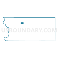
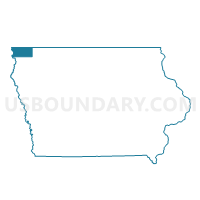
LESTER Voting District, Lyon County, Iowa
About
Outline

Summary
| Unique Area Identifier | 582722 |
| Name | LESTER Voting District |
| County | Lyon County |
| State | Iowa |
| Area (square miles) | 1.82 |
| Land Area (square miles) | 1.82 |
| Water Area (square miles) | 0.00 |
| % of Land Area | 100.00 |
| % of Water Area | 0.00 |
| Latitude of the Internal Point | 43.44029970 |
| Longtitude of the Internal Point | -96.33143710 |
Maps

Graphs
Select a template below for downloading or customizing gragh for LESTER Voting District, Lyon County, Iowa


Neighbors
Neighoring Voting District (by Name) Neighboring Voting District on the Map
- ALLISON TWP W/O LESTER Voting District, Lyon County, IA
- CLEVELAND TWP Voting District, Lyon County, IA
- LARCHWOOD TWP W/O LARCHWOOD & LESTER Voting District, Lyon County, IA
- LOGAN TWP Voting District, Lyon County, IA
Top 10 Neighboring County Subdivision (by Population) Neighboring County Subdivision on the Map
- Larchwood township, Lyon County, IA (1,400)
- Cleveland township, Lyon County, IA (392)
- Logan township, Lyon County, IA (338)
- Allison township, Lyon County, IA (246)